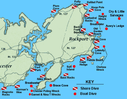
Click on a flag or circle to see the dive site details!!


Click for Rockport, Massachusetts Forecast


Cape Ann Dive Sites Folly Cove Halibut Point Hoop Pole Cove Cathedral Rocks Back Beach Front Beach Old Garden Beach Whale Cove Loblolly Cove Pebble Beach Plum Cove Magnolia Rocks Stage Fort Park Niles Beach Cape Hedge Salt Island Bass Rocks Chester Poling Weck Weck of the Nina T Weck of the Chelsea Weck of the Chelsea Rockport Breakwater Weck of the Chrales Haight Norman's Woe Brace Cove Gloucester Breakwater Avery's Ledge Dry & Little Salvages

Click for Directions

Get Adobe Reader


Pictures from New England


Cape Ann offers some of the best diving in Massachusetts
If you have a dive site that you would like to share with others, please let me know.

 
Plum Cove
Directions: Plum Cove is located along Route 127, on the northeast coast of Cape Ann. Plum Cove is across from the baseball field. Parking is very restricted along the street.
Parking: Okay till 11am after that resident only.
Description: Sandy easy entry, shallow cove, reef outside cove on right. Great place to try out new gear or as a check out dive after a long winter.
Depth: 10' - 20'
Exposure: Northwest
Feature: Nice dive, entry is very easy. Kids love the tide pools.

Folly Cove
Directions: Folly Cove is found on the most northern point of Rockport, right along Route 127. It's six miles north of Grant Circle, the rotary where Routes 128 & 127 meet. There is a sign marked "Folly Cove Landing".
Parking: Very limited resident only. Halibut Pt. is only a short walk away.
Description: One of the most popular shore dives in the area. Rocky entry, sheer wall on left, lots of overhangs. Excellent dive.
Depth: 15' - 60'
Exposure: North East
Feature: Everything you could want in a New England dive. Dive at high tide & calm sea. Great spot for a night dive. Wall Dive
Back to top
Halibut Point
Directions: Follow Route 127 north from downtown Rockport. You will pass Pidgeon Cove on your right. A short distance further up, you will come to Gott Avenue on your right. Follow Gott Avenue to the end. You may park in a private lot or purchase a state parking sticker and use the state park lot.
Parking: For a fee, season passes available at a discount.
Description: Rocky entry. Giant sloping granite slabs descend down to 60'. Good visibilitydue to granite shoreline.
Depth: 15' - 60'
Exposure: All but West
Feature: It requires a 1/4 mile hike through the woods on a well-marked trail with all your gear. The park is a beautiful place for picnics.

Hoop Pole Cove
Directions: Starting from Cape Ann Divers, take a right at top of lot onto Rt. 127 N, follow 127 for approx. 5.0 miles, take a right onto Haven Ave. follow to the end. Take a left, there are 3 access points to the cove along public ways to the Atlantic path.
Parking: 1 block up on Haven or Ocean.
Description: Rocky entry, Great cove with huge rounded boulders, stripers in summer.
Depth: 15' - 35'
Feature: Long walk from parking, = less people. Good lobstering due to plenty of cracks and crevices.
Back to top
Cathedral Rocks
Directions: Cathedral Rocks are located off of Route 127, just north of Pidgeon Cove in Rockport. At the Ralph Waldo Emerson Inn (Phillips Avenue), turn right onto Cathedral Avenue and go to end.
Parking: Very limited on the right.
Description: This is an advanced shore dive.Rocky steep climb to water. Dramatic drop off with boulders.
Depth: 15' - 70'
Exposure: East
Feature: Deepest shore dive on Cape Ann. Best conditions: high tide and calm seas, exit at low tide is difficult due to slippery rocks.

Back Beach
Directions: Follow Route 128 to the end. Take Route 127 north into Rockport. Follow several miles. You'll come to a three-way fork. Take a left staying on 127. Go about 1/4 to 1/2 mile, watch for Beach Street on your right, it's a hard right, almost backwards. Go right onto Beach Street. The beach is on your left.
Parking: Metered spaces
Description: Facing water, left side of has great jetty, middle is sandy, Far right is rocky. Lots of baby flounder in summer.
Depth: 10' - 35'
Feature: Bathrooms, plenty of parking, restaurants nearby. Popular training area. Due to proximity of houses to parking please keep noise to whisper.

Front Beach
Directions: Follow same directions to Back Beach, go straight on Beach St. water on left, over hill next beach on left is Front Beach.
Parking: Metered spaces avail.
Description: Easy sandy entry Rocky on left, sandy out straight and in the middle.
Depth: 10' - 30
Exposure: East & North East
Feature: Bathrooms, kids love this beach, snack bar right across the street. Shopping around the corner. A dive from left of side of Front to right side of Back, is great.
Back to top
Old Garden Beach
Directions: Follow Route 128 to the end and turn left on Route 127 north to Rockport center. Once in Rockport center, turn right on Route 127a, heading back toward Gloucester. Turn left about 100 yards down on Norwood Avenue. Follow Norwood Avenue for several blocks to where the road will turn right for one block. The dive site will be on your left.
Parking: Lot is resident only, unload here and park a few blocks up.
Description: Sandy entry, rocky on right & left sandy in middle. Really pretty dive, Lots of kelp & boulders.
Depth: 15' - 35'
Exposure: North East
Feature: Very, very nice dive.
Back to top

Whale Cove
Directions: Starting from Cape Ann Divers, take right out of lot near Market, take 1st left onto 127A. Go approx. 3.6 miles you'll see Whale Cove Lane, not Rd. take right to end.
Parking: None, unload here and park at High school.
Description: Rocky entry, loose boulders steep climb, good visibility& lobstering.
Depth: 15' - 35'
Exposure: East
Feature: Nobody bothers to dive here due to parking effort, but it's a great dive. Get someone to drop you off.

Loblolly Cove
Directions: Follow Route 128 to the end and takes a left on Route 127a toward Rockport. Once in downtown Rockport, turn right onto Pleasant Street. This is still Route 127a heading back toward Gloucester. About 2 miles from downtown, watch for Penaznce Road on your left. Loblolly Cove will be at the end when you reach the water.
Parking: Resident only, unload here park at Pebble 1/2 mile.
Description: Sandy entry inside cove, point is rocky entry. Cove is shallow w/ lots of life, point is breathtaking with crevices & drop offs.
Depth: 10' - 20'
Exposure: East
Feature: Very Shallow. Cove warms in summer, point is worth the swim.
Back to top

Pebble Beach
Directions: Follow Route 128 to the end and takes a left on Route 127 toward Rockport. After several blocks, turn right on Marina Drive and follow it to Route 127a. Turn left onto Route 127a and follow it for several miles to South Street, Turks Head Motor Inn will be on your right. Turn right onto South Street, then left on Penzance Road. Pebble Beach is directly on your right
Parking: Lots of it! Free!
Description: Sandy entry, facing water pretty rock reef on right end. Lots of flounder & skate in sand. Good lobstering on reef.
Depth: 10' - 35'
Exposure: South East
Feature: Parking is free, great place to spend to day.


Cape Hedge
Directions: Same as Pebble, but go to end of South Street , it over looks the beach.
Parking: Resident only, park at Pebble.
Description: Similar to Pebble, at south end of beach headland is good place to see stripers in the summer.
Depth: 10' - 35'
Exposure: South East
Feature: Nice rock reef on left, headland on right has interesting rock formations.
Back to top

Bass Rocks
Directions: Follow Route 128 to the end and go STRAIGHT through the lights to Bass Avenue. Turn left onto Bass Avenue. Stay on Bass Avenue, which turns into Nautilus Avenue. At the intersection with Atlantic Road, turn left and proceed along the coast. This section of coastline is called Bass Rocks, so park, if you can, and dive.
Parking: Weekdays & Sat. till noon.
Description: Rocky entry, large boulders, sandy out straight. Easiest at high tide.
Depth: 10' - 35'
Exposure: East, Southeast
Feature: Good lobstering, very pretty dive.


Niles Beach
Directions: Starting from Cape Ann Divers, take a left at top of lot onto Rt. 127 S, at lights take left, at next light go straight onto East Main St. go approx. 1.6 miles, Niles on right.
Parking: Resident only in season, off season parking okay.
Description: Sandy beach entry, sandy bottom, rocks on right.
Depth: 10' - 25'
Exposure: West
Feature: Very protected area, almost always calm.
Back to top

Stage Fort Park
Directions: Take Exit 14 (Route 133) off of Route 128. Go right at the end of the ramp, this is Route 133. Follow Route 133 toward Gloucester. At the intersection of Route 127, turn right and then your first left onto Hough Avenue. Stagefort Park is on your left.
Parking: For a fee in season, free off season.
Description: Sandy beach entry, boulders out straight.
Depth: 10' - 30'
Exposure: South
Feature: Bathrooms, snack bar, volley ball, playground. Harbor seals on rocks Oct. - May.


Norman's Woe
Directions: Take Exit 15 off of Route 128. Turn right onto School Street to Lincoln Street to Route 127. Take a left onto Route 127 to Hesperus Avenue. Go right on Hesperus Avenue and head through the town of Magnolia. One mile past the flagpole in the center of town you will find a parking area on the right.
Parking: Space for a few cars.
Description: Rocky entry, boulders, kelp beds, pretty dive.
Depth: 10' - 35'
Exposure: Southeast
Feature: Long walk from lot (300 yards) = not many people bother = good lobstering. Difficult entry/exit

Magnolia Rocks
Directions: Take Exit 15 off of Route 128. Turn right onto School Street to Lincoln Street to Route 127. Take a left onto Route 127 to Hesperus Avenue. Go right on Hesperus Avenue and head through the town of Magnolia. One block past the flagpole in the center of town, turn right onto Lexington Street. Follow it to the water and the dive site.
Parking: Resident only , park a few blocks up. Both sides of Lexington Street.
Description: Rocky entry, very similar to Bass Rocks.
Depth: 10' - 40'
Exposure: Southeast
Feature: Divers see a lot of marine life in the rocks.

Boat Dives
Salt Island & Salt Island Ledge
Boat Dive: It is 200 yards off of Gloucester, just south of Emerson Point. Salt Island Ledge is east-southeast of Salt Island, appearing on nautical charts as an island with a ledge right next to it. These rock outcroppings just off shore are great, easy dives. Depths run 35-60 feet.
Back to top
Rockport Breakwater
Boat Dive: Originally conceived as a public works project during the 1930's, the large man-made structure was never completed. The middle section rises 20 feet out of the water. Awesome dive, giant granite blocks from 0' - 60'. The breakwater is located one mile east of Rockport Harbor. Get a chart, as much of it is submerged.

Brace Cove & Bemo Ledge
Boat Dive: Brace Cove is on the southeastern end of Eastern Point in Gloucester. Bemo Ledge is just out side the cove. The cove is 20'-30' deep and the bottom is mostly sand. The ledge is hard bottomed.

Gloucester Breakwater
Boat Dive: The Gloucester Breakwater affords an easy, relaxed dive with excellent visibility and the remains of an old fishing wreck. You can dive either the inside or outside of the jetty. Most divers say that the outside is the pretty of the two. Depths at this site drop down to about 50 with a sandy bottom.

Wreck of the Chelsea
Boat Dive: Bow of tanker, in 60' - 70' of water, broken up. Sunk on February 10, 1957 while being towed by the Coast Guard. Just Northeast of Thacher Island off Rockport.

Wreck of the Chester Poling
Boat Dive: Oil tanker split in half and sank on January 10,1977. The upright stern section sits in 95', just outside Gloucester Harbor.
Back to top
Wreck of the Gannet
Boat Dive: 70' long wooden trawler, sunk in Sept. 1997. Intact and upright, nice dive, close to the Poling. 90+ ft.

Wreck of the Nina T
Boat Dive: 70' long wooden trawler, sunk in Sept. 1997. Intact and upright, nice dive, close to the Poling. Just like Gannet. 90+ ft.

Wreck of the Charles Haight
Boat Dive: The Charles S. Haight was a liberty ship sunk 1946, depth about 45'. The Haight was 432 feet long with a 57 foot beam. Great dive, lots of sea life on it. Bow portion intact laying on side. Very pretty dive. Off Rockport.

Dry & Little Salvages
Boat Dive: The Salvages are east-southeast of Rockport Harbor. The Dry Salvages are partially exposed, while the Little Salvages are completely under water. A very dramatic site with quick drop-offs, large rocks and cracksin the stone to explore.

Avery's Ledge
Boat Dive: Located just outside Rockport Harbor. It is found on the south end of the Rockport Breakwater. This ledge is made up of rock boulders, rubble and large slab rock. It starts very shallow, then drops to over 80 feet, where the bottom turns to smaller rock and gravel.